3D Surface
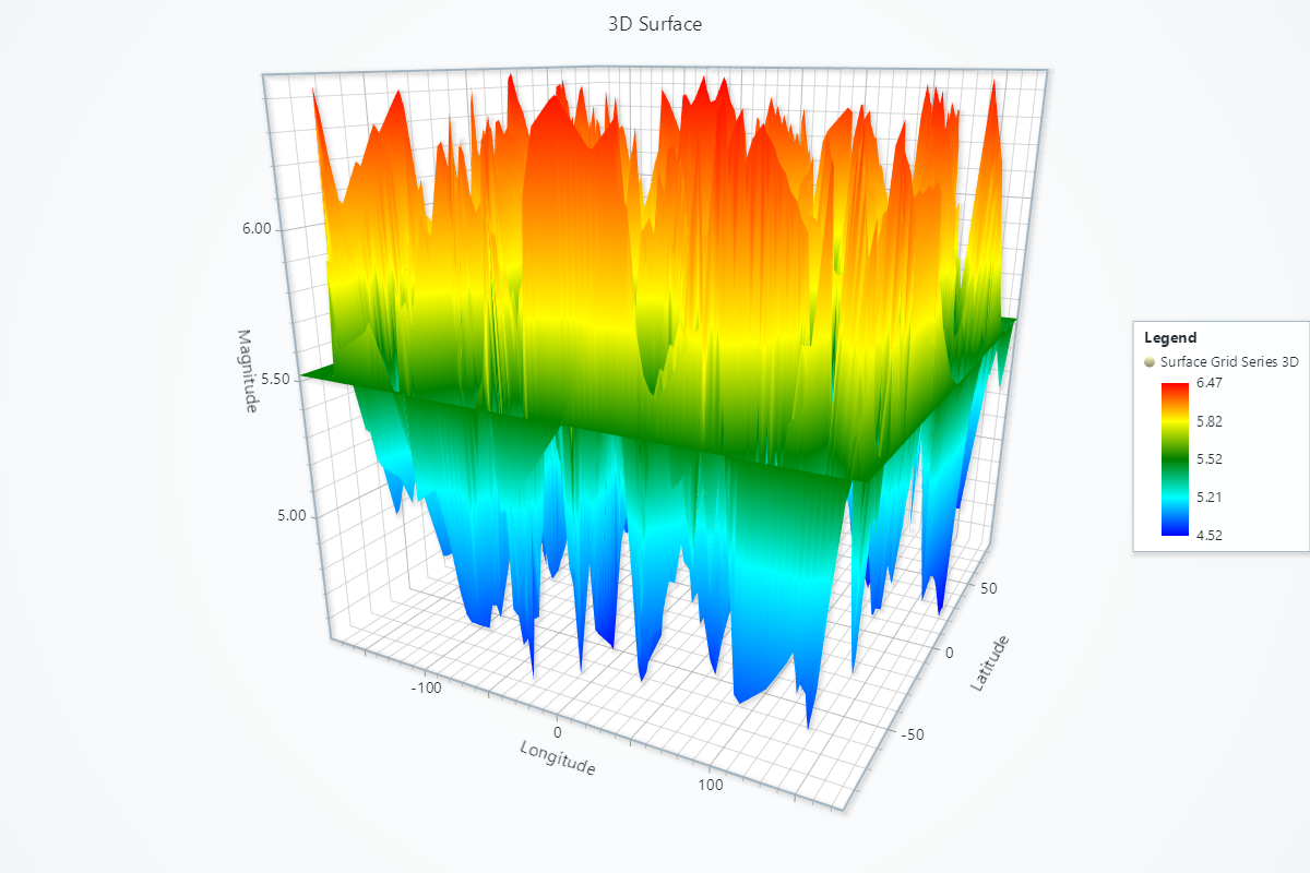
3D surfaces can be created using Chart3D and Surface Grid Series. This series is optimized for massive amounts of surface grid data.
The grid is defined by imagining a plane along X and Z axis, split to < COLUMNS > (cells along X axis) and < ROWS > (cells along Z axis). The total amount of < CELLS > in a surface grid is calculated as columns * rows. Each < CELL > can be associated with DATA from an user data set.
See also Scrolling 3D Surface.
import numpy as np
import lightningchart as lc
from scipy.interpolate import griddata

# Set your license key here
lc.set_license('my-license-key')

# Generate random data points
np.random.seed(0)
num_points = 500

# Generate random latitudes and longitudes
latitudes = np.random.uniform(-90, 90, num_points)
longitudes = np.random.uniform(-180, 180, num_points)
magnitudes = np.random.uniform(4.5, 6.5, num_points)

# Create a grid for interpolation
grid_lat, grid_lon = np.meshgrid(
    np.linspace(latitudes.min(), latitudes.max(), 100),
    np.linspace(longitudes.min(), longitudes.max(), 100)
)

# Interpolate magnitudes onto the grid
grid_mag = griddata(
    (latitudes, longitudes), magnitudes,
    (grid_lat, grid_lon),
    method='linear'   # You can use 'linear' or 'cubic'
)

# Fill NaN values with the mean of magnitudes
nan_mask = np.isnan(grid_mag)
grid_mag[nan_mask] = np.nanmean(magnitudes)

# Create a 3D chart
chart = lc.Chart3D(
    theme=lc.Themes.Light,
    title='3D Surface Grid Series'
)

# Create a surface grid series
surface_series = chart.add_surface_grid_series(
    columns=grid_mag.shape[1],
    rows=grid_mag.shape[0]
)

# Set the start and end points
surface_series.set_start(x=longitudes.min(), z=latitudes.min())
surface_series.set_end(x=longitudes.max(), z=latitudes.max())

# Set the steps
surface_series.set_step(
    x=(longitudes.max() - longitudes.min()) / grid_mag.shape[1],
    z=(latitudes.max() - latitudes.min()) / grid_mag.shape[0]
)

# Set the height map
surface_series.invalidate_height_map(grid_mag.tolist())

# Hide the wireframe
surface_series.hide_wireframe()

# Set palette colors
surface_series.set_palette_coloring(
    steps=[
        {"value": np.nanmin(grid_mag), "color": ('blue')},
        {"value": np.nanpercentile(grid_mag, 25), "color": ('cyan')},
        {"value": np.nanmedian(grid_mag), "color": ('green')},
        {"value": np.nanpercentile(grid_mag, 75), "color": ('yellow')},
        {"value": np.nanmax(grid_mag), "color": ('red')}
    ],
    look_up_property='value',
    percentage_values=False
)

# Invalidate intensity values
surface_series.invalidate_intensity_values(grid_mag.tolist())

# Set axis titles
chart.get_default_x_axis().set_title('Longitude')
chart.get_default_y_axis().set_title('Magnitude')
chart.get_default_z_axis().set_title('Latitude')

chart.open()